


• Intuitive navigation
• Stunning color photographs
• Printable political & terrain maps
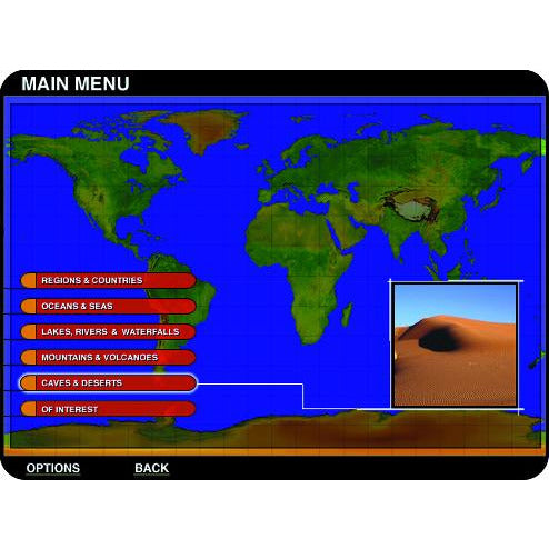
• Globe View makes finding the information and maps you need easier than ever. Navigate the world with a point and click interface.
• Just click on any country, and there are maps, photos, and information right at your fingertips.
• Over a thousand interesting trivia facts from around the globe.
• Hundreds of international flags in full color.
• Feature maps showing average annual precipitation, average temperatures, population density, vegetation, and elevation.
• Detailed statistics and information on important oceans, seas, lakes, rivers, waterfalls, mountains, volcanoes, deserts, caves, international organizations, shipwreck sites, and places of mystery.
• Printable political and terrain maps of over 250 nations and territories, plus all U.S. states and Canadian provinces.
• Updated information on population, climate, GDP, labor force, exports, currency, languages, ethnic and religious groups, states, major cities, and more.
Windows® 10, 7
Pentium® 133 MHz or faster
64 MB RAM (96 MB recommended)
90 MB hard disk space
• Stunning color photographs
• Printable political & terrain maps
• Globe View makes finding the information and maps you need easier than ever. Navigate the world with a point and click interface.
• Just click on any country, and there are maps, photos, and information right at your fingertips.
• Over a thousand interesting trivia facts from around the globe.
• Hundreds of international flags in full color.
• Feature maps showing average annual precipitation, average temperatures, population density, vegetation, and elevation.
• Detailed statistics and information on important oceans, seas, lakes, rivers, waterfalls, mountains, volcanoes, deserts, caves, international organizations, shipwreck sites, and places of mystery.
• Printable political and terrain maps of over 250 nations and territories, plus all U.S. states and Canadian provinces.
• Updated information on population, climate, GDP, labor force, exports, currency, languages, ethnic and religious groups, states, major cities, and more.
Windows® 10, 7
Pentium® 133 MHz or faster
64 MB RAM (96 MB recommended)
90 MB hard disk space